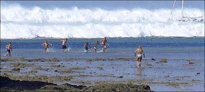
Tourists try to rush to safety before the tsunami hit the Hat Rai Lay Beach in Thailand. The water had receded before the deadly wave struck.
Two hours had already passed since the quake, and there was no established model of what a tsunami might do in the Indian Ocean. Ninety percent of tsunamis occur in the Pacific, and that was where most research had been done.
Dr. Titov, a mathematician who works for a government marine laboratory, began to assemble his digital tools on his computer's hard drive: a three-dimensional map of the Indian Ocean seafloor and the seismic data showing the force, breadth and direction of the earthquake's punch to the sea.
Satellite Image of a Tsunami - Where the water drags into the sea first and it will take like five minitutes to build up a giant wave and destroy the whole coast, So Please be alert, When the water drags into the sea, That is a sign of a Tsunami, Longer it drags higher the waves will be - Chanuka
Be sure and open the picture for a shock of your life to see what the tsunami looked like just before hitting Puket, Thailand. This picture is not a fake. It appears to have been taken from a hi-rise building window in downtown Phuket Thailand. The power of nature is hard to comprehend, especially the destructiveness of water.


No comments:
Post a Comment